show video detail
Aussie Cyclone Update April 7th 2014
- Published_at:2014-04-07
- Category:Science & Technology
- Channel:Oz Cyclone Chasers
- tags:
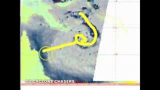
- description: Oz Cyclone Chasers are now in PRE-PLANNING MODE TC Ita is expected to move west and intensify into a Severe Tropical Cyclone before making landfall on the Peninsula or North Tropical Coast. Today's timeline is as follows: Please remember you do not have to watch the whole thing, just the bits that interest you. 0:00 - 3:50 - What we expect to happen and the track maps 3:50 - 7:35 - TC Ita on satellite and microwave imagery now 7:35 - 17:50 - Where the models have Ita crossing, and the longer term potential for a recurve - PLEASE NOTE Models do not accurately forecast intensities so take intensity estimates with a grain of salt - we expect intensities to be stronger than modelled. 17:50 - 24:15 - Discussion about the Upper Level steering patterns in play 24:15 - 25:35 - brief discussion about rainfall potential. Next update Tuesday night Thanks for watching another OCC Cyclone Update and if you'd like to support us you can let you friends know about OCC, download our iTunes/Android app, click on a website ad that interests you, buy an OCC stubby cooler/shirt/sticker from our shop or simply donate to us on our website. Thanks for your continued support.
| ranked in date | views | likes | Comments | ranked in country (#position) |
|---|---|---|---|---|
| 2014-04-09 | 9,347 | 0 | 4 |
( ,#64) ,#64)
|